Đề từ quyển Official Guides for IELTS Cambridge, trang 110
The following maps show the changes that have taken place in the centre of a town since 1700.
Summarise the information by selecting and reporting the main features, and make comparisons where relevant.
Write at least 150 words
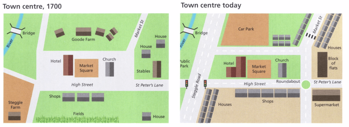
The two maps illustrate how a town centre has changed over a 300-year period since 1700.
Overall, it is clear that although there are some structures removed or remaining unchanged, the whole town centre has experienced great modernisation with more commercial and residential facilities, as well as the renovation of the road system.
As can be seen from the two maps, the market square, which is right in the centre of the town, and the Church, located to the right of the market square, have not changed in 300 years. Another feature that has remained the same is the bridge crossing the river north west of the town centre. In contrast, the expansion of the hotel to the left of the market square has occurred, and the hotel is now almost twice the size it was in 1700. Also, Goode Farm north on the town centre in 1700 has now been replaced with a car park and three rows of houses. In the 1700s, there were stables located to the right-hand side of the church. However, the map of the town centre today shows that they �have been replaced with a block of flats. The two houses north of the stables have also been transformed into two rows of houses.
Steggle Farm, which can be seen in the bottom left-hand corner of the 1700s map, is no longer there. Meanwhile, the row of shops that can be seen in the bottom centre of both maps has changed little over the years. To be more specific, it has been relocated to the corner of the newly-built crossroad between High street and St. Peter's Lane, and two more shops have been added. There was a house and some green fields in the bottom area of the 1700s map, but they have been removed now, leaving vast open spaces. According to the map at present, there is a newly-constructed supermarket at the bottom right hand corner.
Regarding the road system, though many of their names have remained the same, all of the roads are renovated and extended, especially the width of Steggle Road now which is triple that in the year 1700. The traffic lights, roundabout and zebra crossing, which were not needed in 1700, have been now added. Also, the road surfaces have been improved with white road surface markings.
Giáo viên Be Ready IELTS.